Upload your own map image and postals
Use your server's own postal map on the live map. Upload the postals.json from your postal script, upload the map image, and line the image up with the game so units and calls land in the right place.
If your server uses a postal map that isn't one of the ready-made ones, you can upload your own. You need two things from your server's postal script: the postal file, which lists every postal code with its game position, and the map image your players see. Once both are in, you line the image up with the game so a unit at postal 412 shows on the right street.
Do the postals first. The line-up tool uses them to check the image is in the right place.
Before you start#
- You need the Set up the CAD: call types, statuses, penal code, designs and AOP permission.
- Have your postal script's postal file (usually postals.json), or a CSV with code, x and y columns.
- Have the map image as one JPG, PNG or WebP file, up to 30 MB.
- Postals must be ticked at the top of the Postals & streets page. It's on to start with.
Step 1: Upload your postals#
- Open your control panel and click CAD settings in the sidebar.
- Click Map & places along the top, then Postals & streets.
- Under Postals, leave Use a ready-made set on None, I'll upload my own.
- Choose your file under Or upload the postal file. You can also paste the JSON into Or paste it.
- If you already have postals and want to start fresh, tick Replace the postals I have.
- Click Import postals.
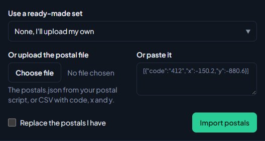
You'll see something like Postals imported: 1687 added, 0 moved. Without Replace the postals I have, a code you already have is moved to its new position rather than added twice.
File formats that work#
The importer reads the JSON that FiveM postal scripts ship, and CSV:
- A list like
[{"code":"412","x":-150.2,"y":-880.6}]. The code can also be called postal or name, and x and y can sit inside coords or pos. - The same list inside
{"postals": [...]}. - A map like
{"412": {"x": -150.2, "y": -880.6}}. - CSV lines of code, x and y, with or without a header row.
Entries with no code or position, and repeats, are skipped and counted in the message.
Add or remove one postal#
- To add one, fill in Code, X and Y at the bottom of the Postals card and click Add postal. If the code already exists, it's moved instead.
- To remove one, find it with Find a postal and click Delete next to it.
- To clear every postal, click Delete all and confirm.
Step 2: Upload the map image#
- Click Live map under Map & places.
- In the Map image box, choose your image.
- Click Upload image.
Most postal maps (New Postals, OCRP, Big Daddy and most others) are drawn over the game's own map grid, which is 2 wide by 3 tall. If your image is exactly that shape, it's lined up for you and you'll see: Map image uploaded and lined up with the game's map grid. Check the green postal dots sit on the right streets. Otherwise you'll see Map image uploaded. Line it up below so units land in the right place.
Step 3: Line the image up#
The Line up your own map box shows your image with your postals drawn as green dots.
If your map is a standard postal map, click Use the game's map grid, check the dots, then click Save.
If it isn't, line it up with two postals:
- Type a postal code in Postal.
- Click the image exactly where that postal is printed. An orange marker appears.
- Type a second postal, far away from the first, both across and up or down the map.
- Click where that one is.
- The edges are worked out for you and the green dots move. Check they sit on the right streets.
- Click Save in the box on the right.
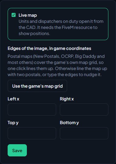
Click Start again to clear your clicks and try again. To nudge the fit by hand, change Left x, Right x, Top y and Bottom y and watch the dots move.
Step 4: Use your map#
Uploading an image switches the live map to Your own map for you. If you pick a ready-made map later and want your image back:
- At the top of the Live map page, under Map, click Your own map.
- Click Save map.
Replace or remove the image#
- To use a new image, choose it and click Replace image. The old one is deleted. If the new image isn't the game grid shape, line it up again.
- To stop using it, click Remove image and confirm. The live map goes back to your postals on a plain background, and the line-up is cleared.
Rules and limits#
- A community can have up to 5,000 postals and 2,000 street names.
- Postal files can be up to 2 MB.
- Map images can be up to 30 MB. WebP or JPG keeps big maps small.
- There's one map image per community. Map tiles can't be uploaded, only a single image.
Something not working?#
It says "No postal codes found. Each one needs a code and x and y numbers." The file isn't in a format the importer knows. Check it's the postal file from your postal script, or a CSV with code, x and y.
It says "That isn't valid JSON." The file or pasted text is broken, often from copying only part of it. Upload the whole file instead of pasting.
It says "Upload a JPG, PNG or WebP image." Convert the map to one of those formats and upload it again.
It says "Keep the map image under 30 MB." Save it as WebP or JPG, or make it a little smaller.
It says "Those two are too close together." Pick two postals far apart, across and up or down the map, and click them again.
It says "Type one of your postal codes first." Type a postal code you've imported before clicking the image. If there are no green dots at all, check Postals is ticked on the Postals & streets page.
It says "The right edge has to be east of the left, and the top north of the bottom." The edges are the wrong way round. Click Use the game's map grid, or line the image up again with two postals.
The live map shows postals on a plain background instead of my image. Two things are needed for the image to show: Your own map picked under Map, and all four edges filled in under Edges of the image, in game coordinates. Check both, then click Save.
Units are in the sea or on the wrong streets. The image isn't lined up. Check the green dots on the Live map page and line it up again.
See also
Choose a map and postal set for the live map
Switch on the live map, pick a ready-made map that matches your server's postal script, load the matching postals, and decide how postals and street names work on calls.
Set up the CAD for your community
Install the CAD, set up the departments that sign on to it, give your staff access, and work through the CAD settings in the order that gets you running fastest.
Import records into the CAD
Bring characters, vehicles, firearms, charges, flags, call types and statuses in from a spreadsheet, or move a whole LonexCAD v3 community across. Check every row before it's saved, and undo an import for 24 hours.
Can't find what you need?
Open a ticket in our Discord and someone from the team will help. Found a bug, or missing a feature? Tell us on the feedback board.